

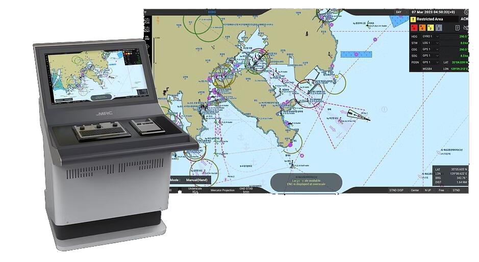
• Enables the navigator to plan the voyage and monitor the route, easier and faster, for safe navigation of the vessel at sea
• Uses various types of data from multiple sources including the GPS and AIS, then displays the images on the electronic navigational chart
• Reads information about specified areas and triggers alerts when the ship enters a hazardous area where the risk of collision or grounding is higher
The MNS-100E series offers powerful route planning and route monitoring capabilities as well as support for electronic navigation charts.
Real-time data on ship position, speed, and course, along with other navigational information, provides a comprehensive view of the ship's surroundings
Provides accurate and reliable navigation information, helping to ensure the safe and efficient passage of the ship
Provides alerts and warnings if the ship is in danger of grounding or colliding with another vessel, helping to ensure safe navigation
Helps the navigators optimize the ship’s route and performance so that time and fuel consumption can be reduced
Fully compliant with MED regulations: DNV and the Republic of Korea government certified
Integrates with other shipboard systems, such as the Automatic Identification System (AIS) and the radar system, to provide a comprehensive view of the status of the ship, route, and the sea
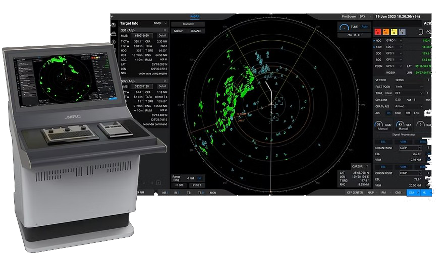
• Enhances situational awareness for safe navigation at sea
• Detects, tracks, and displays objects around the vessel on the screen
• Reads information about specified areas and triggers alerts when the ship enters hazardous areas where the risk of collision or grounding is higher
The MNS-100R series offers powerful object detection and tracking capabilities
Real-time data on ship position, speed, and course, along with other navigational information, provides a comprehensive view of the ship’s surroundings
Provides accurate and reliable object detection, helping to ensure safe navigation even in low visibility conditions
Provides alerts and warnings if the ship is in danger of grounding or colliding with another vessel, helping to ensure safe navigation
Fully compliant with MED regulations, certified by DNV
Integrates with other shipboard systems, such as the Automatic Identification System (AIS) and the ECDIS system, to provide a comprehensive view of the status of the ship, route, and the sea
Always displays the menu bar on the left and the critical vessel data on the right
Adjustable range scales: 0.125 – 96 NM
Manual and automatic tuning and clutter reduction supported
2 Electronic Bearing Lines (EBL), 2 Variable Range Markers (VRM)
Target Tracking: Up to 100 targets, Tracking Range 24 NM; 500 AIS targets
Manual and automatic target acquisition
27-inch display providing visibility with wide viewing angles
The MNS-100R Series provides an intuitive GUI that lets navigators easily utilize the system
User interface ensures important data will be displayed in a fixed position on the screen
| X-Band | S-Band | |
|---|---|---|
| Antenna length | 6ft, 9ft | 12ft |
| Frequency | 9.4GHz | 3.0GHz |
Transmission output | 12kW, 25kW | 30kW |
Rotational speed | 20rpm | |
Pulse length (ns) | 60, 250, 800 | |
| PRF | PRF 3000 (3040, 2900, 3100) / 1500 (1520, 1450, 1550) / 750 (760, 725, 775) | |
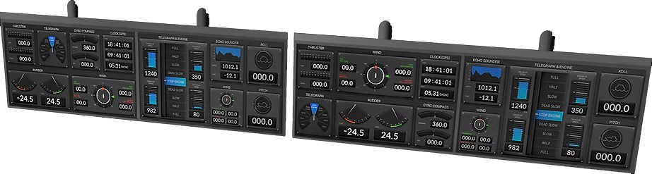
• Provides real-time data and information about the ship’s operation and systems
• Computer-based data acquisition and monitoring system collects and displays the data from the sensors and instruments on the ship
• Provides warnings and alerts if any systems malfunction or require attention
• Intuitively user configurable:
- The display can be configured to match the users’ needs
- The display can dynamically adapt to different situations and change the type of information, which was not possible with analogue instrument panels
• The DIP uses various types of data from multiple sources including but not limited to the gyrocompass, GPS, thruster, and the engines, and displays the images on the overhead display
Real-Time Data
Provides real-time data on the ship's operation and systems, allowing the navigators to monitor and adjust performance as needed
Intuitive Data Visualisation
Collects data from multiple sources, including sensors and instruments, providing a more comprehensive view of the ship's status thatlet the navigators see all the necessary information
User-configurable to match the needs of the navigators and the ship's operations
Provides alerts and warnings if any systems malfunction or require attention, ensuring safe operation of the ship
Integrates with other shipboard systems, such as CCTV and RADAR systems (AIS information included), providing a more comprehensive view of the ship
User Configurable
The user can configure the digital information panel to display the data necessary for the ship’s operations.
The user can also choose the size and location of each instrument on the panel.
· The 13.3” touch display configuration panel controls both starboard side and port side displays


